Sunday, May 15, 2005


Tidy and tight - tank bag is barely visible but is magnetic and secured with a strap, Duffle still has room for souveniers, both panniers secured by latches AND a strap.  Posted by Hello

Saturday, May 14, 2005

What to pack? Where to put it?

One of the things I enjoy about motorcycle travel is the process of paring down the superfluous to the necessary, and then cutting back on the necessary until it will fit in the available. Sometimes even the necessary won't fit, and you have to get creative. I also think it is important that what you carry is secure, can be quickly and easily loaded/unloaded, and that it is readily accessible.

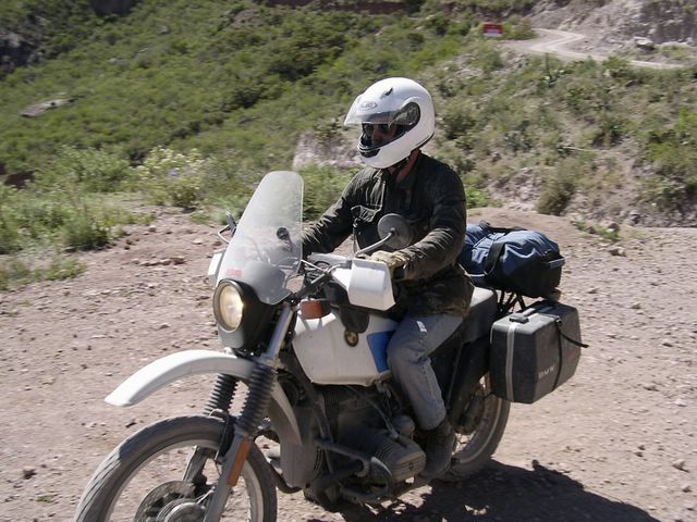
Basically I had four pieces of luggage: a tankbag, L/R panniers, and a small duffel on the tail rack. There is also an under the seat tray for tools, and, of course, the pockets of my riding jacket and jeans.

One should be careful, I think, about what goes in pockets, as these items may become hazardous or even lethal in an accident. Pens and pencils or any other item which can puncture are no-no's. I do like the idea of keeping my cell phone up close and personal, as I have heard of riders laying in a ditch, out of sight of the road, with sufficient injuries to prevent them from attracting would-be rescuers attention but still able to dial 911 to direct the search. Wallet with ID, insurance (auto and health) cards, and money also stay on my person, as well as a zip lock with other vital papers - passport, title, registration, etc. I also kept a small utility ring with an LED flashlight, miniature Swiss Army Knife, compass and thermometer, and whistle in my pocket. In my coat I stored my gloves, ear-plugs (don't leave home without 'em), and sunglasses.

The tank bag was mounted by magnets and was for things of frequent or immediate use such as maps, binoculars (didn't use as much as I thought), camera and battery, extra sunglasses, hard candy lemon drops, bottle of water or camelback bladder, journal and pen/pencil, tire pressure gage, bug spray, sunblock, chapstick, and some assorted snacks of Cliff Bars and Beef Jerky.

On a BMW GS the left pannier is smaller than the right, as it is shaped to fit over the upswept spark arresting exhaust. That one was my workshop. I carried a large MSR fuel bottle with gasoline (about a quart), a small bottle with oil (1pt) (both in socks to prevent banging around and chaffing), a generator rotor stuck inside a roll of duct tape, a diode board in bubble wrap and duct taped to the the top (under the handle) of the bag to keep it dry and relatively safe, a ziplock bag with extra fuel filter, 2 spark plugs, a clutch cable, clutch handle, spare fuses, spare bulbs, a front tire tube and a rear tire tube, a tire inflater kit (8 CO2 cartridges and adapter head), a tube patch kit, jumper cables, a siphon hose, a chamois cloth (to filter gas), JB Weld, and Zip-Ties. There was also a medical kit with standards like cloth tape, gauze pads, gauze roll, band-aids, antibiotic ointment, an oral syringe (for wound irrigation), iodine, pain killers (Aleve), Pepto-Bismal, Lotomil, Ex-Lax, Murine eye wash, tweezers, and small magnifying glass. This pannier, like the other, was mounted on the frame and then additionally secured with a belt.

The right-side pannier was clothing and personals: rain pants, rubber rain boots and gloves, shaving kit: bar soap, shampoo, toothbrush, toothpaste, floss, small washcloth, camp towel, q-tips, deodorant, and two ziplock clothing bags: 2 additional pairs of socks, 2 additional pairs of underwear, 1 additional grey t-shirt, 1 white t-shirt, 1 long sleeved 'adventure' shirt, 1 additional pair of jeans, 1 pair of nylon shorts, 1 pair sandals, and 1 set scrubs for sleeping.

The duffel was camping gear: 2 man backpacking tent, 45 degree sleeping bag, and Thermo-rest pad. There was room for more but why carry more than is needed? This bag was bungeed to the rack with 2 bungees crossed and was very secure.

As it turned out I used the gas (could have had another bottle to make 1/2 gallon or about 20-25 miles but one was enough this time), and the oil, but no other spares. I used all my clothes, but didn't feel like I was offending anyone by the end of the trip (other opinions may be different), and didn't feel like I needed more for cleanliness or for warmth.

For me the key to packing is visualization of what I'm planning to do and what I'll need while doing it. As we didn't plan to make any state visits, I needed no formal clothes, but dining out would require 'relatively' clean clothing and a white t-shirt and jeans will get you by in most places I'd care to eat. Preparing for the unexpected is a personal choice, and while my tools and parts list may seem excessive to some, it gave me great confidence and peace to think I could deal with most foreseeable issues.

Whatever you take, and however you carry it some thoughts are worth noting: secure it so it doesn't move about and CANNOT fall off or shift, pad or pack it so that the constant vibrations and jarring bumps of motorcycle travel will not cause chaffing or friction or outright breakage, keep it to a minimum in weight and complexity for the sake of your bike and your riding partner's patience.

Monday, May 02, 2005


When you get to the bottom safely (but not before), celebrate! Posted by Hello

Did I mention on-coming traffic?  Posted by Hello

Edleweiss, eat your heart out! Yes, that's where we are heading, but it's still only half way to Batopilas! Posted by Hello

The wide pull-off overlooking La Bufa Bridge. Posted by Hello

A pull-off; for dodging oncoming traffic or to allow 'safe' contemplation of the wonders around you. Posted by Hello

Gas is available in Batopilas. Operator lives above the station and when I offered the boy a candy wanted one too! Posted by Hello

Which Way Did They Go? Daze 5-9

Creel is the jumping off point for hikers, bikers (powered and, uh, underpowered), and a stop for the Copper Canyon Train. It is a busy town, with restaurants, an internet cafe, museums, and even a Best Western Lodge (if you find yourself missing the good old US of A so much that you can swallow nearly a hundred dollar difference between the Best Western and, say, Hotel Margaritas where the rooms are 37.50USD for 2 including dinner and breakfast!). CHH23 or 25 (what did you roll?) is well paved and of normal width except that like most Mexican roads there is little or no shoulder onto which you may escape if necessary or on which to stop for photographs. This section south of Creel also gets fairly high traffic with tour buses and bicyclers (underpowered bikes) so as you leave town keep your head on a swivel both for the scenery AND the road traffic.
Some 74km south of Creel is Samachique and another PEMEX station. Gas here, and cinch up your kidney belt as you are about to start some serious dirt roading. While CHH23 (?) bears off east to Guachochi, follow the sign to Quirare - La Bufa - BATOPILAS, the trip's destination at the bottom of this portion of the Copper Canyon. Immediately you will have the opportunity to explore as there is an unmarked intersection just 1km from pavement. The adventurous can veer right, and will wind up on a logging trail that is not shown on any map I was able to obtain. I do not know it's designation (if any) or destination (if any), but it was fun for the 20Km or so I rode it before the deteriorating condition and lack of canyon-like cliffs made me suspicious enough to apply my broken Spanish to a logger catching a smoke in his truck. "La Bufa"? big eye roll, heavy drag on the cigarette and gestures back up the trail. "Batopilas?" more smoke, more gestures, followed by a definite arc upward with his hand. Translated this means "you foolish Norte Americano, you should have stayed to the left at the 1Km marker and gone UP rather than to the right and gone DOWN. Now you must go back and have wasted 2 hours." Well, wasted is relative, as the scenery here, as elsewhere was tremendous. The ridges we crossed were arid and had only sparse vegetation, while the valleys were lush with grass and trees and small rancheros and haciendas.
So, bear left at the fork at 1Km marker, and keep attentive for Km markers to ensure you are on the correct bit of dirt. The first 35Km of the 65Km dirt road to Batopilas twists and winds through small villages and rancheros, and will surprise you with small stands of Aspen among the pines. It feels like riding though a National Park or Forrest, and in fact you are - the Parque Natural Barranca Del Cobre. There is at least one small school along the way, and many children, so have a care and take hard candy treats if you want to be a hero. All this is well do-able on most any 'street' or 'standard' bike. Around Quirare the gloves come off, however, and you will spend the rest of the trip with a cliff going up on one side, and a cliff going down on the other. Neither is preferable as you are also facing the possibility of oncoming traffic forcing you into one while the scenery draws you over the other. TAKE CARE AND SLOW DOWN. While the road surface was not nearly as bad as I had read, the dust will be a major factor for traction, engine wear, and visibility. It is also a traffic signal - if you notice a feather of dust ahead or around the corner find the nearest pull off (which may be only wide enough for a tire width and one foot) and wait for whatever is coming. All materials in/out of the canyon travel by truck - including broken down trucks, and a motorcycle looses in the battle of gross tonnage nearly every time. Another reason to pull off is to appreciate the vistas the canyon is presenting: shear cliffs (on your side and across the canyon), spectacular views of the river far below, mountain goats, horses and burros, and the occasional Tarahumara Indian on a foot path. Another signal of road condition, one familiar to hunters, was the luggage on my compadre's motorcycle. His Helen's Bags were attached by two points to the rack, and if the road ahead grew too bumpy for our current speed they would flap and flash like a white tailed deer catching a scent, allowing me plenty of time to back off the gas and slow down. At one point is a large pull off, suitable for gathering the troops if you are traveling in a group, overlooking La Bufa Bridge and a set of (dirt) switchbacks that make the Edelweiss Alpine Tour Ad (you know the one) look like a 1/4 mile drag strip. La Bufa Bridge is about half way on your journey. It took between 3 and 4 hours to cover the 65Km of dirt, which works out to 10mph or less. You can mark your progress by how high above the river you are, and when you finally merge at Batopilas you can feel justifiably proud of your day's ride.
Though there are more roads to smaller and smaller villages a the bottom of the canyon and perhaps a trail that could be followed to Urique and out the western edge of Copper Canyon, for us the next day was just the reverse of the previous. On a whim we opted to try a one day exit from Mexico, a choice I made, but now regret as I should have spent the day thus gained by exploring the city of Batopilas and the neighboring countryside. However, it has been proven that one can, if necessary, extricate oneself from the furthest point in the trip in but a single, butt-searing, mind-numbing 12 hour ride.
Gas IS available in Batopilas, as well as a mechanic and desponchardo (tire shop), so fill up before you start. Back up through the canyon, with minimal photography (there are some shots you CANNOT pass) to Samachique and the pavement of CHH23 towards Guachochi. Having just left the soul hugging canyon, it is now time for some rubber burning twisties and wide-open views, and my partner and I were once again proclaiming "It can't get any better than THIS!", though, as before, it always did. Gas is available just outside Guachochi, and the road home winds through piney forests to Balleza and San Francisco Del Oro, but if you aren't experimenting with time/distance travel, visit the city of Guachochi for it is the capitol of the Tarahumara Indians, and I'm sure filled with fascinating information on their way of life. Between Samachique and San Francisco Del Oro the farmers/ranchers have layed incredible stone fences to mark their property. I cannot imagine this were completed in one life-time, as they stretch mile after mile across the pastures and fields and up some impossible hills. The road or the scenery - where is your focus?
CHH23 gets a little anemic between SFDO and Hidalgo Del Parral, and but there is a wide smooth bypass loop around Parral that will be easy - once it gets lane markings on it. We picked upt MEX45 Cuarto just east of Parral to Jimenez, and again north of Jimenez to Camargo and made good time. It was actually a relief to ride straight pavement for a change! Cost was about 3.50$ per moto for each segment. Don't forget to ask (beg) for a Chihuahua State Map at the toll plazas and note - the only police seen the entire trip were on these sections of tollway.
Gas-ing up at Camargo we were under a time crunch. My GPS verified that we were racing the setting sun to make it back the 224Km to Ojinaga/Presidio. Read and Heed: DO NOT RIDE AT NIGHT IN MEXICO - DO NOT RIDE AT NIGHT IN MEXICO - DO NOT RIDE AT NIGHT IN MEXICO!!
1) a black cow on a black road on a black night is damned hard to see 2) on those rare occasions when the lanes ARE painted they lack the reflective particles we have in the US, so they are not as easily seen 3) the dust flying about can reduce visibility to less than 1/4 mile in a heartbeat, which is what you will hear pounding in your ears when you cannot see where you are going! We entered Ojinaga under just such conditions, 30 minutes past sunset, and survived to pass the information.
Leaving the country requires that you surrender your vehicle sticker, your tourist card and have your passport stamped. Also that you surrender a buck fifty to the border guard (?). It'll sound nice when the US Customs agent says "Citizenship?", answer:"US", "Welcome home".
Back to Priata Inn to wake up the attendant or pull her from TV with the night call button. Oh, and if it's after 9pm (it was for us) don't count on any more exotic dinner than can be gleaned from the shelves of the Fina Store just north of the border. Come to think of it, it was a VERY exotic dinner.
Day 7 was another headbanger to get to the Lake Belton BMW Rally. Up Rt67 through Marfa and Alpine, then across I-10 to pick up a pleasant ride on FM864 just past Sonora, up to RT190 through Brady (Heart of Texas) and all the way to Belton and the rally. Re-entering Texas I decided that the Creator, in His kindness, sprinkled wildflowers like some gay camouflage to cover up the dreariness of West Texas. They were notably absent in Mexico where the scenery was breathtaking on its own. Kileen and Belton were re-indoctrination to the land of Mc-fast food, used car lots and 'Mexican' Restaurants, but the campgrounds were a welcome oasis of friendly faces and BMW rondels. It was our 15 minutes of fame.
Day 8 was spent running about the Austin area in a pack of 25, doing the accordion thing at stop lights, and winding like a serpent through the country side. I couldn't stop comparing houses to haciendas.
Day 9 went right up the super slab I-35 to Waxahachie and a brief visit to Scarborough Faire before Rt287 to Arlington and home.